REVIEW · PAGE
Horseshoe Bend and Lake Powell Self-Guided Tour
Book on Viator →Operated by Shaka Guide Apps · Bookable on Viator
That curve in the Colorado hits fast. This self-guided audio tour turns the Page-to-Horseshoe Bend/Lake Powell drive into a story-led route with GPS directions and an offline map, so you’re not hunting for what to see next. I love that it’s private by vehicle and you can skip stops you’re not in the mood for. I also like how the route mixes big viewpoints with a few doable hikes—so it’s not just pull-offs and photos.
One thing to keep in mind: the experience is app-based. If GPS pickup is spotty, the tour can feel like it’s fighting you, especially at the start or if you jump into the route mid-way.
In This Review
- Quick hits before you go
- How this self-guided GPS audio tour really plays out
- Bitter Springs to Antelope Pass Vista: a strong start with big geology
- Horseshoe Bend: the view is worth it, but timing controls your comfort
- Antelope Canyon: don’t show up hoping it’s walk-in easy
- Powell Museum & Archives: a quick stop that adds context
- Glen Canyon Dam Overlook + Carl Hayden Visitor Center: two stops, one story
- Potato Hill, Rim Trail, and Grandview: easy walks with payoff
- The Chains + Hanging Gardens: slickrock, and the water says be careful
- The Chains
- Hanging Gardens Trail
- Navajo Mountain, Wahweap viewpoints, and the Marina: finish the loop with choices
- If you want more than overlooks: Skyline Arch trails, Lone Rock Beach, and Big Water
- Value and timing: how long should you block on your calendar?
- The biggest practical gotchas (so you don’t waste your money)
- Who this tour is best for
- Should you book the Horseshoe Bend and Lake Powell self-guided tour?
- FAQ
- How much does the Horseshoe Bend and Lake Powell self-guided tour cost?
- How long does the tour take?
- Is it one ticket per person?
- Does the tour work offline?
- Do I need to download an app?
- What language is the tour offered in?
- Do tour access passes expire?
- Are parking and entrance fees included?
- Can I cancel and get a full refund?
- Where is the tour starting point and where does it end?
Quick hits before you go
- Offline audio + GPS directions mean you can drive without relying on cell service.
- One price per group (up to 15) makes it cost-effective if you’re traveling with friends or family.
- Horseshoe Bend’s parking gets tight at common day-part times, so plan your arrival.
- Most stops are “stop, look, walk a bit”—perfect if you want variety without a full day of strenuous hiking.
- Antelope Canyon requires reservations (and the tour can’t replace that).
- Some trail areas are close to deep water—use caution where slickrock meets the lakeshore.
How this self-guided GPS audio tour really plays out
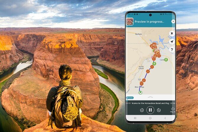
This tour is built for car time. You download the Shaka Guide app, redeem your code, then the narration and directions guide you as you drive. The audio runs automatically as you move through the route, so you don’t have to stop every few minutes to read your phone.
What you’ll notice quickly is the tone: practical and trip-focused. It’s not just facts about rock formations. It’s also the kind of info that helps you decide what’s worth your time—like which viewpoints pair well with short walks, or how long to plan for a stop so you’re not stuck watching the crowd surge behind you.
Because it’s a single vehicle tour, this is where the value really shows. At $11.99 per group (up to 15), the price works out nicely compared with typical per-person activities—especially if your group wants to do several stops instead of one big one.
The catch: you still pay real-world costs. The tour notes that parking at Horseshoe Bend and Wahweap Recreation Area is not included, plus there can be entrance fees connected to certain sites/areas. In other words, you’re paying for the “guide in your car,” not for the parks themselves.
Other Horseshoe Bend we've reviewed at Antelope Canyon & Northern Arizona


Bitter Springs to Antelope Pass Vista: a strong start with big geology
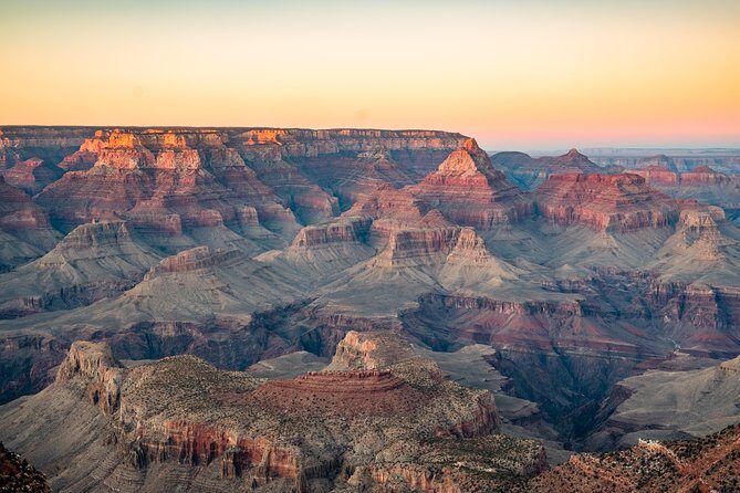
You start at Bitter Springs, Arizona, and the route loops back there when you’re done. Even though the tour is called Horseshoe Bend and Lake Powell, the route begins with a “warm up your eyes” viewpoint.
The first stop is Antelope Pass Vista on the western side of Highway 89. This is one of those overlooks where you can instantly tell why northern Arizona is so famous for geology: long views across Vermillion Cliffs National Monument, near the Utah line. There’s no long hiking requirement here—just a good, quick reset before you roll into the famous river bend.
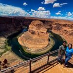
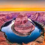
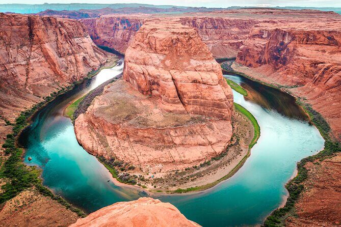
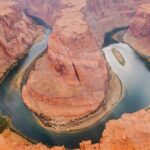
Horseshoe Bend: the view is worth it, but timing controls your comfort

Horseshoe Bend is the star. From the overlook, you see the Colorado River curving around a sandstone formation from about a 1,000-foot-tall cliff. There’s also an approx. 1.5-mile hike associated with the area, plus a parking lot with restrooms.
Here’s the practical part: it gets crowded. The tour info flags busy periods roughly 9–11 a.m. and 4:30–6:30 p.m. During those windows, the parking lot can fill up, and no parking is allowed on Highway 89. If parking is full, you may have to circle back later rather than forcing it.
Parking is also on you: $10 for car or RV is listed for Horseshoe Bend, and it’s not included in the tour price.
My advice: if Horseshoe Bend is your main mission, arrive either earlier than you think you should or later than the obvious rush. It’s one of those spots where your experience can shift from pleasant to stressful mostly because of timing, not because of the view.
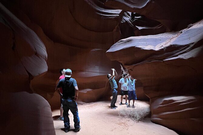
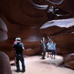
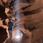
Antelope Canyon: don’t show up hoping it’s walk-in easy
Right after Horseshoe Bend, the route points you toward Antelope Canyon. This is a slot canyon on the Navajo Nation near Page, known for narrow, winding passages and colored light created by erosion and flash floods.
Two big practical notes matter most:
- You need prior reservations to visit.
- There are two main sections. Upper Antelope Canyon is accessed through guided tours, while Lower Antelope Canyon requires a hike.
This matters because the audio tour can help you plan and understand what you’re seeing, but it can’t replace reservation requirements. If you want Antelope Canyon as part of your trip, lock that down before you go.
Powell Museum & Archives: a quick stop that adds context
Before you start stacking viewpoints, the tour includes Powell Museum & Archives on Lake Powell Boulevard in Page (inside the museum).
This isn’t just a random building stop. It’s named after a one-armed explorer and the first European American to cross the Colorado River. The exhibits cover geology, archaeology, dam history, paleontology, and culture. If you’ve ever stared at a canyon wall and wondered what forces built it, this kind of stop gives you words for what you’re about to see outside.
This is a good “take a break” stop too—about 30 minutes—especially if the sun’s already doing its thing.
Other Lake Powell Tours we've reviewed at Antelope Canyon & Northern Arizona


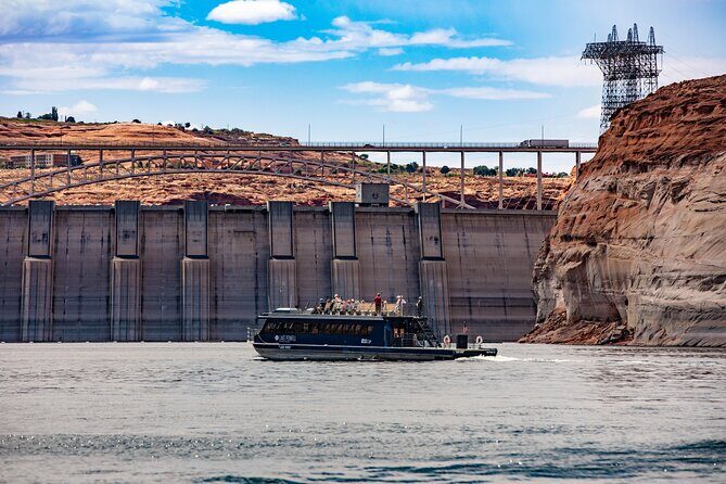
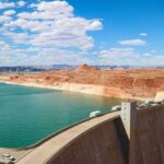
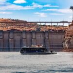
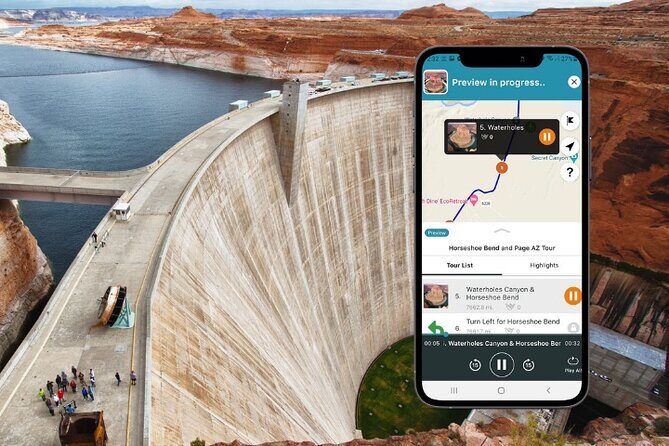
Glen Canyon Dam Overlook + Carl Hayden Visitor Center: two stops, one story
Next up is the Glen Canyon Dam Overlook. This is an easy one—accessible from Scenic View Road with a walk under 1,000 feet. You’ll get a north-looking view of the dam and the Colorado River. There are picnic tables and a pavilion, which makes it easy to linger without feeling like you’re blocking traffic.
After that, the tour brings you to Carl Hayden Visitor’s Center, located across the Glen Canyon Bridge (two miles north of Page). Since it’s physically tied to the dam, it works as a “wait, what am I looking at?” checkpoint.
Hours vary by season (summer 8 a.m.–6 p.m., winter 8 a.m.–4 p.m., spring/fall 8 a.m.–5 p.m.). It’s also noted as closed on several holidays including Christmas and New Year’s Day.
If you’re doing this in a shorter time window, I’d prioritize the overlook first. Then decide if you have time for the visitor center depending on how your day feels.
Potato Hill, Rim Trail, and Grandview: easy walks with payoff
Lake Powell days can turn into a grab-bag of short stops. This part of the route keeps it lighter and more walk-friendly.
You’ll see mentions of Rim Trail / Lake View Trailhead, Potato Hill Overlook, and Grandview Overlook. The tour info says Potato Hill has about a one-mile round-trip walk to the overlook. It also connects to Page Rimview Trail, a loop around Page that’s listed as just over 10 miles (16 km) and popular for birding and biking.
Grandview Overlook comes shortly after and is described as peaceful, with panoramic views that include Lake Powell and Navajo Mountain.
The value here is simple: you get the big scenic reward without committing to a long hike. These are also good for photographers because you’re walking to vantage points rather than just parking and staring.
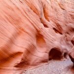
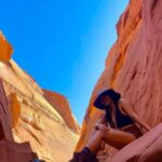
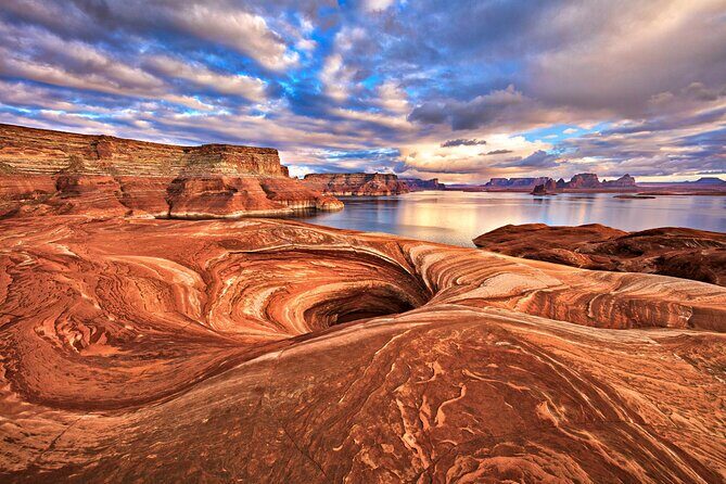
The Chains + Hanging Gardens: slickrock, and the water says be careful
Now you shift from “easy overlooks” to “active terrain.”
The Chains
This is described as an easy to moderate self-guided adventure through slickrock sand formations. Expect views of canyon walls and the Glen Canyon Dam. Lakeshore access is possible depending on current lake elevations, which means conditions can change day to day.
The tour specifically warns: use extreme caution by the water because it can be very deep here.
Trailhead directions are given in detail:
- Take the first right on the gravel road after Ridge Way heading toward Glen Canyon Dam before the Glen Canyon Bridge.
- Take a left at the end past Hanging Gardens trailhead.
- Keep going to the parking area at the dead end.
Hanging Gardens Trail
Then you get a classic out-and-back: 1.2 miles (2 km) round trip. The highlight is the name itself—plants that grow on vertical rock surfaces. It’s a straightforward distance, but in desert country, even 1.2 miles can feel like more when the heat is strong.
My honest take: this is where the audio tour earns its keep. You’re more likely to find the right turnoffs and start points when someone narrates the route and gives you a logical flow.
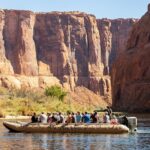
Navajo Mountain, Wahweap viewpoints, and the Marina: finish the loop with choices
As you keep driving, you’ll hit viewpoint stops aimed at Lake Powell and the surrounding peaks.
You’ll reach Navajo Mountain Viewpoint, where Navajo Mountain is described as sacred to the Navajo people. It’s also given an attention-grabbing scale: about the height of seven Empire State Buildings. Just past that is Wahweap Viewpoint, with wonderful views across the water.
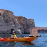
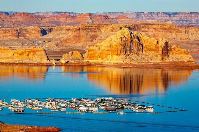
Then comes Wahweap Marina. This is where you can step out, explore the shoreline, and (depending on your time) use the area for meals and shopping. The tour notes Lake Powell Resort is there, and that restaurants and shops are open to non-hotel guests.
After that is Wahweap Recreation Area, reached by an entrance station. It’s described as having restrooms centrally located near the group area (with several restroom buildings). The tour also notes $30 per car for Wahweap Recreation Area parking, and again that parking isn’t included.
Finally, the route ends with Wahweap Overlook. This last stop is a good place to decompress, especially if you’ll keep exploring after the audio tour ends—since it gives you a chance to look back at what you’ve already seen.
If you want more than overlooks: Skyline Arch trails, Lone Rock Beach, and Big Water
The tour information also includes extra stop ideas that can extend your day beyond the core “Page highlights.”
You’ll see guidance starting from Page down Highway 89 south, turning right onto Bullhead City Road, then continuing to reach a Stud Horse Point Trailhead. The next trailhead is Skyline Arch Trailhead. Both are described as about 1.5 miles and moderate with some elevation gain. Along the way you’ll get vistas of Lake Powell and sandstone cliffs, finishing with a view of Skyline Arch.
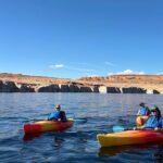
Then there’s Lone Rock Beach, described as offering views of Lake Powell and its namesake rock. It’s also noted for sandy beach camping, plus activities like swimming, kayaking, and off-roading.
And if you want indoor time or a break from driving, the route mentions Big Water Visitor Center with dinosaurs, geology exhibits, and adventure tips for Lake Powell.
These added stops are ideal when you want the audio tour as a spine for your day, not a hard schedule.
Value and timing: how long should you block on your calendar?
The tour is listed as 1 to 8 hours. That range is realistic because you can keep it simple—just hit the signature overlooks—or you can build in the trail portions and extra stops.
If you’re short on time:
- Prioritize Horseshoe Bend early or late to dodge the hardest crowd windows.
- Add Antelope Pass Vista and one or two viewpoints around Potato Hill/Grandview.
- Skip longer hikes like The Chains unless you’re motivated that day.
If you have a half-day or more:
- Add at least one trail besides Horseshoe Bend.
- Include Powell Museum and either the dam overlook or visitor center for context.
- End at Wahweap with time to walk near the marina.
Also note: the app guidance says it plays automatically as you drive and works fully offline. That means your real constraint is daylight and heat, not data coverage.
The biggest practical gotchas (so you don’t waste your money)
The tour is generally smooth—when the phone behaves. A few issues come up in the real world, and you can plan around them.
- Don’t change your starting point mid-route. The tour is designed to flow in one direction. If you start “in the wrong place,” you may get repetitive direction prompts.
- Download ahead with strong Wi‑Fi. The instructions specifically say to download the tour using strong Wi‑Fi before you go.
- Do a quick GPS check before you commit. If GPS isn’t picking up your location right away, expect delays at the start.
- Know what costs are still separate. Parking at Horseshoe Bend and Wahweap Recreation Area and some entrance fees are not included, even if some stops are described as free in the route notes.
Finally, the tour is offered in English, and it’s a mobile ticket. Service animals are allowed, and most people can participate since it’s driven and self-guided.
Who this tour is best for
This is a great fit if:
- You want flexibility. Start when you want and stop when you want.
- You like learning while driving, but you don’t want a formal group tour.
- You’re doing Page for a couple days and want to “connect the dots” between geology, the dam, and the viewpoints.
- You’re traveling in a group where a per-vehicle price matters.
It may be less ideal if:
- You hate app setup or you’re traveling with limited phone battery/data confidence.
- You’re the kind of traveler who wants zero navigation friction.
- You’re visiting Antelope Canyon without reservations (because that part requires booking).
Should you book the Horseshoe Bend and Lake Powell self-guided tour?
I’d book it if you like the idea of a guided voice in your car plus choose-your-own-stop flexibility. At $11.99 per group up to 15, it’s one of the better-value ways to add context to the Page area—especially if you’re already planning to drive between Horseshoe Bend and Lake Powell.
Skip it (or think twice) if app reliability is a deal-breaker for you. Some people run into GPS/app issues, and that can turn a scenic day into a troubleshooting session.
If you do book: download ahead, keep location services on, and treat it like a smart co-pilot. Then go early or late for Horseshoe Bend, reserve Antelope Canyon if you want it, and let the route do the heavy lifting while you focus on what’s actually out the window.
FAQ
How much does the Horseshoe Bend and Lake Powell self-guided tour cost?
It’s $11.99 per group, up to 15 people. That’s the price for the tour for your group/vehicle.
How long does the tour take?
The tour is listed as lasting about 1 to 8 hours, depending on how many stops you make and how much hiking or time you spend at each place.
Is it one ticket per person?
The tour is described as one tour per vehicle/group, so the cost is not based on per-person admission fees for the audio experience.
Does the tour work offline?
Yes. The tour includes an offline map, and audio/GPS guidance is designed to work without needing continuous Wi‑Fi or data.
Do I need to download an app?
Yes. You redeem the tour in the Shaka Guide app and use the app to launch and follow the GPS-activated narration.
What language is the tour offered in?
The tour is offered in English.
Do tour access passes expire?
No. The tour never expires.
Are parking and entrance fees included?
Parking at Horseshoe Bend and Wahweap Recreation Area is not included. Entrance fees are also not included, including an $8 fee listed for the John Wesley Powell Museum and a $15 per person fee listed for Glen Canyon National Recreation Area.
Can I cancel and get a full refund?
Yes, free cancellation is available up to 24 hours in advance for a full refund.
Where is the tour starting point and where does it end?
It starts at Bitter Springs, AZ and ends back at the meeting point.